Email
PRESS RELEASE: Husted Announces Announce New Broadband Mapping Resource to Identify Gaps in Coverage
| From | Lt. Gov. Husted Comms <[email protected]> |
| Subject | PRESS RELEASE: Husted Announces Announce New Broadband Mapping Resource to Identify Gaps in Coverage |
| Date | March 1, 2022 4:03 PM |
Links have been removed from this email. Learn more in the FAQ.
Links have been removed from this email. Learn more in the FAQ.
io and bo
*FOR IMMEDIATE RELEASE:*
March 1, 2022
*MEDIA CONTACT:
*Hayley Carducci | (614) 404-8616
?
Husted, BroadbandOhio Announce New Mapping Resource
to Identify Gaps in Coverage
"Effort will help guide broadband expansion efforts in Ohio"
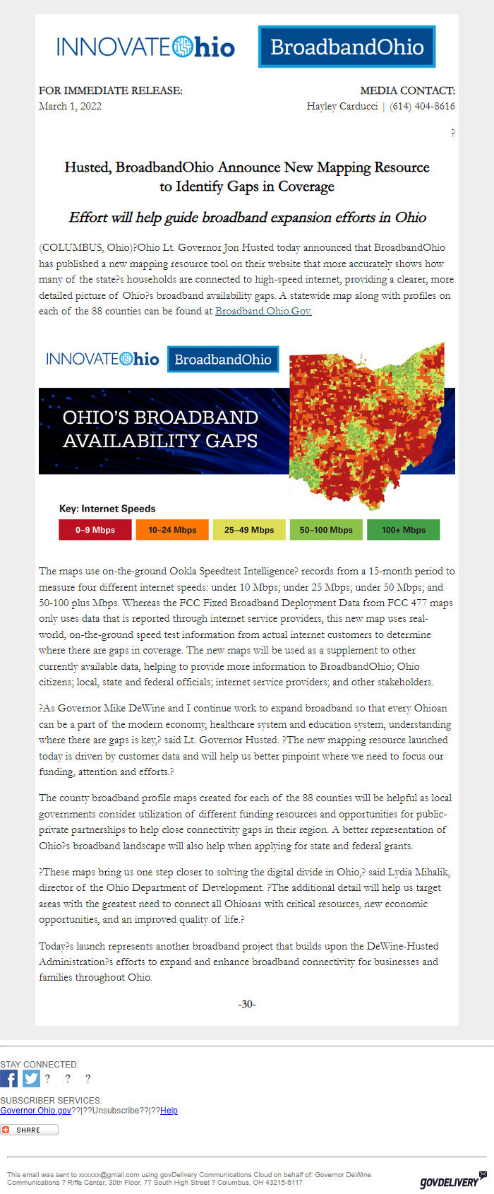
(COLUMBUS, Ohio)?Ohio Lt. Governor Jon Husted today announced that BroadbandOhio has published a new mapping resource tool on their website that more accurately shows how many of the state?s households are connected to high-speed internet, providing a clearer, more detailed picture of Ohio?s broadband availability gaps. A statewide map along with profiles on each of the 88 counties can be found at _Broadband.Ohio.Gov [ [link removed] ]._
Broadband Maps
The maps use on-the-ground Ookla Speedtest Intelligence? records from a 15-month period to measure four different internet speeds: under 10 Mbps; under 25 Mbps; under 50 Mbps; and 50-100 plus Mbps. Whereas the FCC Fixed Broadband Deployment Data from FCC 477 maps only uses data that is reported through internet service providers, this new map uses real-world, on-the-ground speed test information from actual internet customers to determine where there are gaps in coverage. The new maps will be used as a supplement to other currently available data, helping to provide more information to BroadbandOhio; Ohio citizens; local, state and federal officials; internet service providers; and other stakeholders.
?As Governor Mike DeWine and I continue work to expand broadband so that every Ohioan can be a part of the modern economy, healthcare system and education system, understanding where there are gaps is key,? said Lt. Governor Husted. ?The new mapping resource launched today is driven by customer data and will help us better pinpoint where we need to focus our funding, attention and efforts.?
The county broadband profile maps created for each of the 88 counties will be helpful as local governments consider utilization of different funding resources and opportunities for public-private partnerships to help close connectivity gaps in their region. A better representation of Ohio?s broadband landscape will also help when applying for state and federal grants.
?These maps bring us one step closer to solving the digital divide in Ohio,? said Lydia Mihalik, director of the Ohio Department of Development. ?The additional detail will help us target areas with the greatest need to connect all Ohioans with critical resources, new economic opportunities, and an improved quality of life.?
Today?s launch represents another broadband project that builds upon the DeWine-Husted Administration?s efforts to expand and enhance broadband connectivity for businesses and families throughout Ohio.
*-30-*
________________________________________________________________________
STAY CONNECTED: Visit us on Facebook [ [link removed] ] Visit us on Twitter [ [link removed] ] ? ? ?
SUBSCRIBER SERVICES:
Governor.Ohio.gov [ [link removed] ]??|??Unsubscribe [ [link removed] ]??|??Help [ [link removed] ]
Bookmark and Share [ [link removed] ]
________________________________________________________________________
This email was sent to [email protected] using govDelivery Communications Cloud on behalf of: Governor DeWine Communications ? Riffe Center, 30th Floor, 77 South High Street ? Columbus, OH 43215-6117 GovDelivery logo [ [link removed] ]
*FOR IMMEDIATE RELEASE:*
March 1, 2022
*MEDIA CONTACT:
*Hayley Carducci | (614) 404-8616
?
Husted, BroadbandOhio Announce New Mapping Resource
to Identify Gaps in Coverage
"Effort will help guide broadband expansion efforts in Ohio"
(COLUMBUS, Ohio)?Ohio Lt. Governor Jon Husted today announced that BroadbandOhio has published a new mapping resource tool on their website that more accurately shows how many of the state?s households are connected to high-speed internet, providing a clearer, more detailed picture of Ohio?s broadband availability gaps. A statewide map along with profiles on each of the 88 counties can be found at _Broadband.Ohio.Gov [ [link removed] ]._
Broadband Maps
The maps use on-the-ground Ookla Speedtest Intelligence? records from a 15-month period to measure four different internet speeds: under 10 Mbps; under 25 Mbps; under 50 Mbps; and 50-100 plus Mbps. Whereas the FCC Fixed Broadband Deployment Data from FCC 477 maps only uses data that is reported through internet service providers, this new map uses real-world, on-the-ground speed test information from actual internet customers to determine where there are gaps in coverage. The new maps will be used as a supplement to other currently available data, helping to provide more information to BroadbandOhio; Ohio citizens; local, state and federal officials; internet service providers; and other stakeholders.
?As Governor Mike DeWine and I continue work to expand broadband so that every Ohioan can be a part of the modern economy, healthcare system and education system, understanding where there are gaps is key,? said Lt. Governor Husted. ?The new mapping resource launched today is driven by customer data and will help us better pinpoint where we need to focus our funding, attention and efforts.?
The county broadband profile maps created for each of the 88 counties will be helpful as local governments consider utilization of different funding resources and opportunities for public-private partnerships to help close connectivity gaps in their region. A better representation of Ohio?s broadband landscape will also help when applying for state and federal grants.
?These maps bring us one step closer to solving the digital divide in Ohio,? said Lydia Mihalik, director of the Ohio Department of Development. ?The additional detail will help us target areas with the greatest need to connect all Ohioans with critical resources, new economic opportunities, and an improved quality of life.?
Today?s launch represents another broadband project that builds upon the DeWine-Husted Administration?s efforts to expand and enhance broadband connectivity for businesses and families throughout Ohio.
*-30-*
________________________________________________________________________
STAY CONNECTED: Visit us on Facebook [ [link removed] ] Visit us on Twitter [ [link removed] ] ? ? ?
SUBSCRIBER SERVICES:
Governor.Ohio.gov [ [link removed] ]??|??Unsubscribe [ [link removed] ]??|??Help [ [link removed] ]
Bookmark and Share [ [link removed] ]
________________________________________________________________________
This email was sent to [email protected] using govDelivery Communications Cloud on behalf of: Governor DeWine Communications ? Riffe Center, 30th Floor, 77 South High Street ? Columbus, OH 43215-6117 GovDelivery logo [ [link removed] ]
Message Analysis
- Sender: Office of the Ohio Lt. Governor
- Political Party: n/a
- Country: n/a
- State/Locality: n/a
- Office: n/a
-
Email Providers:
- govDelivery