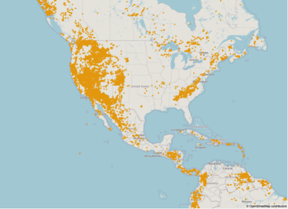
| THE HILL REPORT A Favorability Map Is a Ranking, Not a Finding Connor Hill · InsightfulWord · September 16, 2026  There is a real federal program applying machine learning to mineral assessment, it has been documented publicly since 2022, and what it does is almost exactly the opposite of what the phrase suggests to a general reader. The program is a collaboration between the American defense research agency and the federal geological survey. Its purpose is to compress the time required to produce a formal mineral resource assessment, which had been running to roughly two years for a single deposit type using manual methods. The bottleneck it attacks is not geology. It is paperwork. Decades of geological maps and reports exist as scanned images and printed documents, and extracting the information from them into a machine-readable form is a manual task of enormous scale. That is what the automation does. Officials describing the work have stated it plainly: the process for pulling data from maps and documents, compiling it, and making it analysis-ready has been automated. Pilot assessments demonstrated a workflow running start to finish in about two and a half days. What the output is, however, has not changed. A mineral resource assessment is a probabilistic statement about deposits that have not been found, in areas where the geology permits them, using statistical models built from deposits that have been found elsewhere. It is not a location. It is not a quantity anyone can extract. And the agencies themselves state that generated assessments still have to pass scientific standards and peer review before they are adopted, which means the machine output is an input to a process rather than a conclusion from one. The gap between that and a map of found deposits is the entire subject, and the methodology that defines the gap has been published for decades and is not difficult to follow. What follows is what the program was built to do, the three parts of a formal assessment, why the training data necessarily points backward, why a probability is not a deposit, and what would turn a favorable area into a discovery. What the Program Was Built to Do The motivation is a statutory obligation running into a practical constraint, and both are on the record. Legislation passed in 2020 directed the geological survey to assess the country's critical mineral resources. The agency tracks well over a hundred commodities, a large number of which meet criticality thresholds on supply-risk grounds. Producing a formal assessment for each of those, by the established method, at roughly two years per deposit type, is arithmetic that does not work. The program exists to change the arithmetic. The approach was to move the workflow from a serial, largely manual, intermittently updated process to a parallel, continuous, machine-assisted one. The tasks targeted were document and map processing rather than interpretation. That focus is the informative part. The scarce resource in mineral assessment is not ideas about where deposits might be; it is the labor of assembling the underlying observations into a consistent dataset. Geological maps from different eras use different symbologies, projections, unit names and conventions, and reconciling them has historically consumed most of the effort. A competition run in 2022 to develop these capabilities, followed by pilot assessments and structured development events through 2024, produced the working pipeline. The published accounts describe extraction and compilation, not discovery. The difficulty of that extraction is easy to underrate. A single geological map encodes unit boundaries, fault traces, dips and strikes, a legend whose symbols vary by publishing era, and a projection that may predate modern datums. Converting a scanned sheet into georeferenced features that a model can use is a problem in computer vision and cartography rather than in earth science, which is exactly why it was tractable to automate. The Three Parts of a Formal Assessment The method that the output feeds into has been standard for decades, is documented in published short courses, and consists of three distinct operations. | 📌 Fresh Signal Two years to 2.5 days The reduction in the time required to run a critical mineral resource assessment workflow demonstrated by a joint program of the U.S. Geological Survey and the Defense Advanced Research Projects Agency. What was automated is the extraction of geospatial data from maps and documents and its compilation into analysis-ready form — not the interpretation. Generated assessments still have to pass the survey's scientific standards and peer review before adoption. Source: DARPA, USGS collaborate to accelerate critical mineral assessment, 2025. | | Support or oppose: should probabilistic resource assessments be published with a plain-language statement of what they are not? Supporters argue that these documents are routinely quoted as though they located something, that the misreading is predictable and consequential where public land is involved, and that a short standard preface would cost an agency nothing. Opponents answer that the methodology is already stated in every report, that scientific publications should not be written around the possibility of misquotation, and that a disclaimer would be stripped out by exactly the people who misquote them. Which is better? Hit reply — one line is enough. | The first part delineates permissive tracts: geographic areas where the geology permits deposits of a specified type to exist. Boundaries are drawn from mapped rock units and extended using geophysical surveys that detect permissive rocks under cover. The word permissive is carrying the weight. It means the geology does not rule the deposit type out. It does not mean anything is there. The second part builds grade and tonnage models. Frequency distributions of the grades and tonnages of well-explored deposits of a type serve as statistical models for the undiscovered ones — on the reasoning that deposits of the same type tend to resemble one another. The third part estimates how many undiscovered deposits the tract contains, expressed as a probability distribution rather than a number. The published description is explicit that these estimates represent the probability, or degree of belief, that some fixed but unknown number of undiscovered deposits exists. Combining the three produces a probabilistic statement about metal that might be present in an area. Every word in that sentence is doing necessary work, and the compressed versions that circulate keep none of them. Why the Training Data Points Backward The machine-learning component introduces a specific limitation that is well described in the technical literature and is structural rather than fixable. A model that predicts where deposits are must be trained on places where deposits are known to be. Those are the only labeled positive examples available. This makes the model a formalization of the resemblance between unexplored ground and ground where discoveries were already made. It is genuinely useful — resemblance is real information, and the established assessment method rests on the same premise. It also means the model is structurally incapable of identifying a deposit type nobody has found yet. The negative examples are worse. There is no reliable register of places confirmed to contain nothing, because confirming absence requires drilling that was never funded. Practitioners construct negative samples by various conventions, each of which imports an assumption about what non-prospective ground looks like. The imbalance is extreme. Known deposits are vanishingly rare relative to the area being classified, which is a recognized problem in this literature with its own methods and its own failure modes — a model can achieve excellent accuracy by predicting that nothing is anywhere. And the training locations themselves carry a sampling bias. Discoveries cluster where exploration happened, which followed roads, terrain, land access and historical accident as much as geology. A model trained on that pattern learns exploration history alongside ore genesis, and cannot separate them. None of this makes the technique unsound. It makes it a tool for prioritizing where to spend exploration money, which is what its developers say it is. A Probability Is Not a Deposit The step from an assessment to a quantity of metal involves several conversions, each of which loses something. | Context — what a resource assessment implies about any particular company A probabilistic estimate of undiscovered deposits in a region is not a statement about any firm's assets. It does not establish that anything will be found, that a discovery would be economic, that the ground is available, or that a company holding claims nearby has any relationship to the assessed material. Assessments are inputs to public land-use and policy decisions, and are published for that purpose. Nothing here is a comment on any specific company, sector or security, and none of it is a recommendation. | The assessment output is a distribution over the number of undiscovered deposits, combined with distributions over their possible grades and tonnages. Multiplying through gives a distribution over contained metal, not a figure. That distribution has a long tail and a substantial probability mass at or near zero for many tracts. Quoting its mean, or worse its upper percentile, as the resource is a misuse that the methodology documentation specifically warns against. The grade and tonnage models describe premining figures at the lowest cutoff grade — the total metal the deposit contained before anyone touched it, including material that would never be economic to extract. They are deliberately not economic estimates. There is no economic filter anywhere in the three parts. The method is designed to describe what the geology could hold, precisely so that the economic question can be asked separately against whatever prices and costs prevail when it is asked. And the assessments are for undiscovered deposits by construction. Material already identified is excluded from them, because the purpose is to estimate what remains to be found. The unit of the estimate is also worth noticing. The method counts deposits, not tons, and a deposit in this framework is defined by the model type it belongs to. A tract credited with a handful of undiscovered deposits of a low-tonnage type and one credited with the same number of a high-tonnage type describe very different quantities behind an identical-looking number. What Turns a Tract Into a Discovery The distance between a favorable area and a mine is measured in years and in drill meters, and each stage is documented. Reconnaissance comes first: geological mapping, geochemical sampling of soils and stream sediments, and geophysical surveys over the favorable ground. This narrows an area measured in thousands of square kilometers to targets measured in hundreds of hectares. Drilling is the only step that establishes whether anything is present. A target becomes a discovery when holes intersect mineralization of a grade and width that justifies continuing, and the great majority of drilled targets do not. Delineation follows: enough drilling on a close enough spacing to establish continuity and estimate tonnage and grade with defined confidence, which is what permits classification under securities disclosure rules. Studies come next — metallurgical test work establishing recovery, then engineering and economic studies at successive levels of precision, each of which can and frequently does terminate the project. Permitting and financing run alongside and after, and each has its own attrition. The base rate across that sequence is the number worth carrying. The industry's own figures for the proportion of identified prospects that become operating mines are very small, and the proportion of favorable ground that ever hosts a drill hole is smaller still. The composite point is that a machine-assisted assessment is a faster way of producing a document that says where it is worth looking, that the document has always said that, and that the interval between saying it and knowing anything runs through drilling nobody has yet paid for. | The bill, not the debate The federal program applying machine learning to mineral assessment automated the extraction of data from old maps and documents, compressing a two-year workflow to about two and a half days. What it produces is a probabilistic estimate of undiscovered deposits in areas where geology permits them, with no economic filter and no located ore — and it still goes through peer review. When a map is described to you as having found something, is the word permissive anywhere in the description? Connor Hill reads every reply. | Sources checked Connor Hill · InsightfulWord |