|
Sinlahekin, Okanogan:
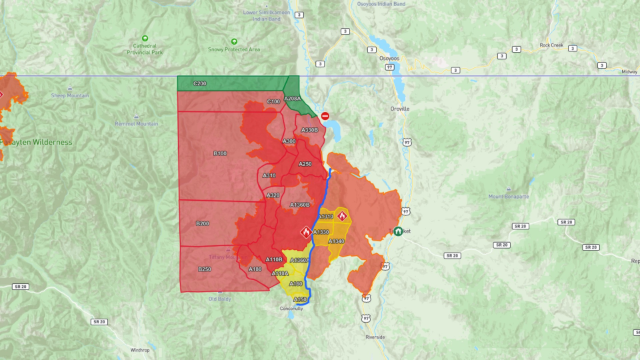
A significant change in weather is expected over the next few days as warm and dry conditions give way to cooler temperatures and increased moisture. Wetting rain across the fire’s perimeter should help moderate overall fire activity and provide crews with more favorable conditions for suppression, containment, and mop-up activities. However, excessively wet conditions may create challenges for heavy equipment operations and driving on muddy roads. Across the fire area, resources remain engaged improving and securing containment line, mopping up heat, and conducting ongoing, critical suppression repair work. As temperatures warmed up throughout the day Tuesday, activity increased along the northwest side of the fire and where most of the heat remains.
Yesterday, a helicopter assisted ground resources with bucket work northeast of Olie Pass as interior pockets of fuel burned throughout the day. Additionally, an infrared flight discovered a .10-acre spot fire in the Pasayten Wilderness. In the Iron Gate-area, hotshot crews continued building containment line along the fire’s edge east of Middle Fork Road, near the forest and wilderness boundary. As suppression operations move forward so does the critical suppression repair work. Resources are backhauling pumps and hose out of areas where fire suppression activities occurred. Acreage and containment numbers continue to be adjusted as operations personnel verify data through a variety of sources including enhanced field collection data and infrared flights.
- 166,392 acres (+762)
- 38% containment.
- Level 3: GO NOW- A110B, A180, A1360B, A250, A330B, A300, C100, B100, B200, B250
- Level 2: Be Ready- A1310, A1330, A1340, A1360A, A110A, A160,A150
- Level 1: Get Ready- C200, A208A
- Evacuations: Recreation areas between Conconully and Loomis remain closed, and the Loomis State Forest is closed to recreational use.
- Road Closures: Chopaka Road
- Shelters:
Omak Shelter - Omak Community Center
601 Benton Street Omak WA 98841
Large Animal Shelters: The Okanogan County Fairgrounds is open for livestock, If going to the fairgrounds, use the north end race gate entrance
Kaiser Canyon, Okanogan:
NO UPDATES AT TIME OF WRITING
- 138,293 acres (+0).
- 99% containment.
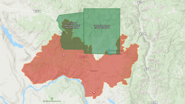
- Level 3: GO NOW- All evacuations lifted
- Level 2: Be Ready- All evacuations lifted
- Level 1: Get Ready- Armstrong Meadows, Central Peak
- Road Closures: All road Closures lifted
- Shelters:
Lake Roosevelt High School Gym
503 Crest Dr #505, Coulee Dam, WA 99116
Omak Community Center
601 Billy Ives Track Rd, Omak, WA
Omak Public Library
30 Ash St S, Omak, WA 98841, USA
Okanogan County Fairgrounds
175 Rodeo Trail Rd, Okanogan, WA 98840, USA
Omak Stampede Rodeo Grounds
236 Ferry St S, Omak, WA 98841, USA
Ridge Riders Rodeo Grounds
22209 Alcan Rd NE, Grand Coulee, WA 99133, USA
Colwash, Yakima/Benton:
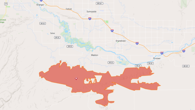
NO UPDATES AT TIME OF WRITING
- 39,073 acres (+0)
- 98% contained.
- Level 2: Be Ready- Evacuation Lifted
- Level 1: Get Ready- Evacuation Lifted
Ptarmigan, Okanogan:
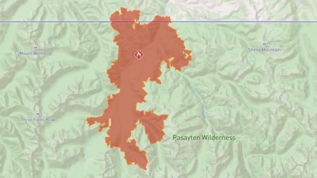
Wet and cooler weather reduced active fire behavior with scattered heat confined to the Middle and West Forks of the Pasayten River. A return to warmer drier weather this week may increase fire activity; wet weather, forecasted mid-week, may further reduce fire activity. Hazardous fuels mitigation and road repair continue on Forest Service Roads 52, 5225 and 5400. Ptarmigan Fire activity has been minimal.
- 25,166 acres (+396)
- 55% contained.
- No current evacuation orders.
- Road Closures: Harts Pass Road
- Rec Sites Affected: Pacific Northwest Trail Recreation - Okanogan-Wenatchee National Forest, East Fork Pasayten Trail, Ptarmigan Ridge Trail, Dean Creek Trail, West Fork Pasayten Trail,Rock Creek Trail - Methow, Hidden Lakes Trail, Tatoosh Buttes Trail, Buckskin Ridge Trail, Slate Peak Trailhead, Pacific Crest Trail - W Fork Methow Trail #480- U.S. Canada border.
*Updated as of 9am PST.
|