| From | Center for Western Priorities <[email protected]> |
| Subject | Look West: Graffiti reported at Arches National Park |
| Date | November 10, 2025 2:44 PM |
Links have been removed from this email. Learn more in the FAQ.
Links have been removed from this email. Learn more in the FAQ.
Look West: Public lands and energy news from the Center for Western Priorities
** Graffiti reported at Arches National Park
------------------------------------------------------------
Monday, November 10, 2025
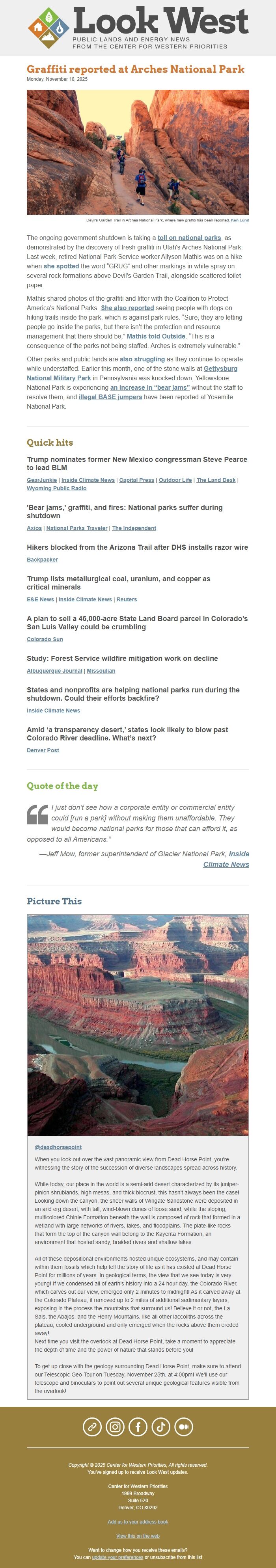
Devil's Garden Trail in Arches National Park, where new graffiti has been reported. Ken Lund ([link removed](9099662215).jpg)
The ongoing government shutdown is taking a toll on national parks ([link removed]) , as demonstrated by the discovery of fresh graffiti in Utah's Arches National Park. Last week, retired National Park Service worker Allyson Mathis was on a hike when she spotted ([link removed]) the word “GRUG” and other markings in white spray on several rock formations above Devil's Garden Trail, alongside scattered toilet paper.
Mathis shared photos of the graffiti and litter with the Coalition to Protect America’s National Parks. She also reported ([link removed]) seeing people with dogs on hiking trails inside the park, which is against park rules. “Sure, they are letting people go inside the parks, but there isn’t the protection and resource management that there should be,” Mathis told Outside ([link removed]) . “This is a consequence of the parks not being staffed. Arches is extremely vulnerable.”
Other parks and public lands are also struggling ([link removed]) as they continue to operate while understaffed. Earlier this month, one of the stone walls at Gettysburg National Military Park ([link removed]) in Pennsylvania was knocked down, Yellowstone National Park is experiencing an increase in “bear jams” ([link removed]) without the staff to resolve them, and illegal BASE jumpers ([link removed]) have been reported at Yosemite National Park.
** Quick hits
------------------------------------------------------------
Trump nominates former New Mexico congressman Steve Pearce to lead BLM
GearJunkie ([link removed]) | Inside Climate News ([link removed]) | Capital Press ([link removed]) | Outdoor Life ([link removed]) | The Land Desk ([link removed]) | Wyoming Public Radio ([link removed])
'Bear jams,' graffiti, and fires: National parks suffer during shutdown
Axios ([link removed]) | National Parks Traveler ([link removed]) | The Independent ([link removed])
Hikers blocked from the Arizona Trail after DHS installs razor wire
Backpacker ([link removed])
Trump lists metallurgical coal, uranium, and copper as critical minerals
E&E News ([link removed]) | Inside Climate News ([link removed]) | Reuters ([link removed])
A plan to sell a 46,000-acre State Land Board parcel in Colorado’s San Luis Valley could be crumbling
Colorado Sun ([link removed])
Study: Forest Service wildfire mitigation work on decline
Albuquerque Journal ([link removed]) | Missoulian ([link removed])
States and nonprofits are helping national parks run during the shutdown. Could their efforts backfire?
Inside Climate News ([link removed])
Amid ‘a transparency desert,’ states look likely to blow past Colorado River deadline. What’s next?
Denver Post ([link removed])
** Quote of the day
------------------------------------------------------------
” I just don’t see how a corporate entity or commercial entity could [run a park] without making them unaffordable. They would become national parks for those that can afford it, as opposed to all Americans.”
—Jeff Mow, former superintendent of Glacier National Park, Inside Climate News ([link removed])
** Picture This
------------------------------------------------------------
[link removed]
@deadhorsepoint ([link removed])
When you look out over the vast panoramic view from Dead Horse Point, you're witnessing the story of the succession of diverse landscapes spread across history.
While today, our place in the world is a semi-arid desert characterized by its juniper-pinion shrublands, high mesas, and thick biocrust, this hasn't always been the case! Looking down the canyon, the sheer walls of Wingate Sandstone were deposited in an arid erg desert, with tall, wind-blown dunes of loose sand, while the sloping, multicolored Chinle Formation beneath the wall is composed of rock that formed in a wetland with large networks of rivers, lakes, and floodplains. The plate-like rocks that form the top of the canyon wall belong to the Kayenta Formation, an environment that hosted sandy, braided rivers and shallow lakes.
All of these depositional environments hosted unique ecosystems, and may contain within them fossils which help tell the story of life as it has existed at Dead Horse Point for millions of years. In geological terms, the view that we see today is very young! If we condensed all of earth's history into a 24 hour day, the Colorado River, which carves out our view, emerged only 2 minutes to midnight! As it carved away at the Colorado Plateau, it removed up to 2 miles of additional sedimentary layers, exposing in the process the mountains that surround us! Believe it or not, the La Sals, the Abajos, and the Henry Mountains, like all other laccoliths across the plateau, cooled underground and only emerged when the rocks above them eroded away!
Next time you visit the overlook at Dead Horse Point, take a moment to appreciate the depth of time and the power of nature that stands before you!
To get up close with the geology surrounding Dead Horse Point, make sure to attend our Telescopic Geo-Tour on Tuesday, November 25th, at 4:00pm! We'll use our telescope and binoculars to point out several unique geological features visible from the overlook!
============================================================
** Website ([link removed])
** Instagram ([link removed])
** Facebook ([link removed])
** TikTok ([link removed])
** Medium ([link removed])
Copyright © 2025 Center for Western Priorities, All rights reserved.
You've signed up to receive Look West updates.
Center for Western Priorities
1999 Broadway
Suite 520
Denver, CO 80202
USA
** View this on the web ([link removed])
Want to change how you receive these emails?
You can ** update your preferences ([link removed])
or ** unsubscribe from this list ([link removed])
** Graffiti reported at Arches National Park
------------------------------------------------------------
Monday, November 10, 2025
Devil's Garden Trail in Arches National Park, where new graffiti has been reported. Ken Lund ([link removed](9099662215).jpg)
The ongoing government shutdown is taking a toll on national parks ([link removed]) , as demonstrated by the discovery of fresh graffiti in Utah's Arches National Park. Last week, retired National Park Service worker Allyson Mathis was on a hike when she spotted ([link removed]) the word “GRUG” and other markings in white spray on several rock formations above Devil's Garden Trail, alongside scattered toilet paper.
Mathis shared photos of the graffiti and litter with the Coalition to Protect America’s National Parks. She also reported ([link removed]) seeing people with dogs on hiking trails inside the park, which is against park rules. “Sure, they are letting people go inside the parks, but there isn’t the protection and resource management that there should be,” Mathis told Outside ([link removed]) . “This is a consequence of the parks not being staffed. Arches is extremely vulnerable.”
Other parks and public lands are also struggling ([link removed]) as they continue to operate while understaffed. Earlier this month, one of the stone walls at Gettysburg National Military Park ([link removed]) in Pennsylvania was knocked down, Yellowstone National Park is experiencing an increase in “bear jams” ([link removed]) without the staff to resolve them, and illegal BASE jumpers ([link removed]) have been reported at Yosemite National Park.
** Quick hits
------------------------------------------------------------
Trump nominates former New Mexico congressman Steve Pearce to lead BLM
GearJunkie ([link removed]) | Inside Climate News ([link removed]) | Capital Press ([link removed]) | Outdoor Life ([link removed]) | The Land Desk ([link removed]) | Wyoming Public Radio ([link removed])
'Bear jams,' graffiti, and fires: National parks suffer during shutdown
Axios ([link removed]) | National Parks Traveler ([link removed]) | The Independent ([link removed])
Hikers blocked from the Arizona Trail after DHS installs razor wire
Backpacker ([link removed])
Trump lists metallurgical coal, uranium, and copper as critical minerals
E&E News ([link removed]) | Inside Climate News ([link removed]) | Reuters ([link removed])
A plan to sell a 46,000-acre State Land Board parcel in Colorado’s San Luis Valley could be crumbling
Colorado Sun ([link removed])
Study: Forest Service wildfire mitigation work on decline
Albuquerque Journal ([link removed]) | Missoulian ([link removed])
States and nonprofits are helping national parks run during the shutdown. Could their efforts backfire?
Inside Climate News ([link removed])
Amid ‘a transparency desert,’ states look likely to blow past Colorado River deadline. What’s next?
Denver Post ([link removed])
** Quote of the day
------------------------------------------------------------
” I just don’t see how a corporate entity or commercial entity could [run a park] without making them unaffordable. They would become national parks for those that can afford it, as opposed to all Americans.”
—Jeff Mow, former superintendent of Glacier National Park, Inside Climate News ([link removed])
** Picture This
------------------------------------------------------------
[link removed]
@deadhorsepoint ([link removed])
When you look out over the vast panoramic view from Dead Horse Point, you're witnessing the story of the succession of diverse landscapes spread across history.
While today, our place in the world is a semi-arid desert characterized by its juniper-pinion shrublands, high mesas, and thick biocrust, this hasn't always been the case! Looking down the canyon, the sheer walls of Wingate Sandstone were deposited in an arid erg desert, with tall, wind-blown dunes of loose sand, while the sloping, multicolored Chinle Formation beneath the wall is composed of rock that formed in a wetland with large networks of rivers, lakes, and floodplains. The plate-like rocks that form the top of the canyon wall belong to the Kayenta Formation, an environment that hosted sandy, braided rivers and shallow lakes.
All of these depositional environments hosted unique ecosystems, and may contain within them fossils which help tell the story of life as it has existed at Dead Horse Point for millions of years. In geological terms, the view that we see today is very young! If we condensed all of earth's history into a 24 hour day, the Colorado River, which carves out our view, emerged only 2 minutes to midnight! As it carved away at the Colorado Plateau, it removed up to 2 miles of additional sedimentary layers, exposing in the process the mountains that surround us! Believe it or not, the La Sals, the Abajos, and the Henry Mountains, like all other laccoliths across the plateau, cooled underground and only emerged when the rocks above them eroded away!
Next time you visit the overlook at Dead Horse Point, take a moment to appreciate the depth of time and the power of nature that stands before you!
To get up close with the geology surrounding Dead Horse Point, make sure to attend our Telescopic Geo-Tour on Tuesday, November 25th, at 4:00pm! We'll use our telescope and binoculars to point out several unique geological features visible from the overlook!
============================================================
** Website ([link removed])
** Instagram ([link removed])
** Facebook ([link removed])
** TikTok ([link removed])
** Medium ([link removed])
Copyright © 2025 Center for Western Priorities, All rights reserved.
You've signed up to receive Look West updates.
Center for Western Priorities
1999 Broadway
Suite 520
Denver, CO 80202
USA
** View this on the web ([link removed])
Want to change how you receive these emails?
You can ** update your preferences ([link removed])
or ** unsubscribe from this list ([link removed])
Message Analysis
- Sender: Center for Western Priorities
- Political Party: n/a
- Country: United States
- State/Locality: n/a
- Office: n/a
-
Email Providers:
- MailChimp