|
For Immediate Release
October 17, 2025
Three-Year Study Redefines Understanding of Manganese Resources in Northern Maine
AUGUSTA, MAINE – The Department of Agriculture, Conservation and Forestry's Maine Geological Survey is pleased to announce the completion of a three-year project focused on detailed, 1:24,000-scale geologic mapping of manganese-bearing rocks in Aroostook County
Manganese is essential for steel production and is also used in aluminum alloys and batteries. The U.S. does not currently produce any manganese and imports 100% of this resource, primarily from Gabon and Mexico. The Aroostook County manganese district represents the largest manganese reserve in the United States.
“This work gives us the most detailed picture ever of Maine’s manganese district,” said Maine State Geologist Dr. Ryan Gordon. “It not only advances science but also helps ensure the U.S. has reliable data on critical mineral resources.”

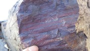
Geologists have been aware of the Aroostook County manganese district in northern Maine for over 150 years, but the last mapping and exploration campaigns were completed 70 years ago, well before modern geological theories were developed. (Photo: Typical banded manganese ironstone of the main deposit at Maple Mountain, Number Nine Lake quadrangle. Additional project photos are linked below.)
The current project collected data on select areas around the City of Presque Isle and Maple and Hovey mountains southwest of Mars Hill. The work was spearheaded by Dr. Chunzeng Wang, a geology professor at the University of Maine at Presque Isle and resulted in three bulletins (detailed reports and maps) for the Presque Isle, Mapleton, and Number Nine Lake 1:24,000-scale map quadrangles.
The project also supported training the next generation of geoscientists by funding the Master's degree of co-author Lauren Madsen at the University of Maine and providing internships for five undergraduate students. The research benefited from the collaboration of international geologists and paleontologists from six countries, who assisted with fossil identification and consultation. The work was made possible by generous access from local landowners.
The project achieved several major research breakthroughs:
- The origin of manganese deposits in northern Maine:
- The studied deposits formed in similar ways, which was precipitation of manganese from seawater on a continental shelf in Silurian time
- Discovery of the Number Nine Mountain tectonic terrane, which is a distinct piece of an ancient tectonic plate that includes three newly defined rock units:
- Arc volcanic rocks of the Middle Ordovician Moorehouse Brook Formation (470 Ma)
- Tectonic mélange of the lower Silurian Nine Lake Formation
- A complete ophiolite sequence at Nineteen Mountain
- Revised the age order (stratigraphy) of rocks that formed during the Silurian and Devonian geologic time periods through the study of a variety of fossils preserved in the rocks (megafossils, conodonts, and pollen) and radiometric age determination (zircon U-Pb dating).
- Characterized regional rock structures created during the Acadian mountain-building event (orogeny) in the Devonian geologic time period. These structures provide evidence of regional compression and deformation:
- Tight folding of rock layers deposited during the Silurian
- Northeast-striking reverse-thrust faults.
The three-year mapping effort was funded by the U.S. Geological Survey’s Earth Mapping Resources Initiative (Earth MRI), a national program dedicated to modernizing geologic data about the United States’ critical mineral resources. These commodities are essential to the nation’s economy, clean energy transition, and national defense, yet their supply chains remain vulnerable to global disruption.
###
|
Project photos courtesy Maine Geological Survey
 |
|
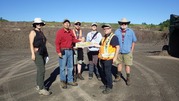
Left to right: Master’s student and co-author Lauren Madsen, lead scientist Dr. Chunzeng Wang, geologist Brian Way, Maine Geological Survey project manager Amber Whittaker, project consultant and academic advisor Dr. David Lentz from the University of New Brunswick, project consultant and academic advisor Dr. Martin Yates from the University of Maine. |
 |
|
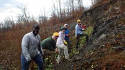
Left to right: Undergraduate interns Preston Bass and Liam Daniels, Master’s student and co-author Lauren Madsen, project consultant and reviewer Robert Marvinney (former Maine State Geologist), and Maine Geological Survey project manager Amber Whittaker. |
 |
|
Typical banded manganese ironstone of the main deposit at Maple Mountain, Number Nine Lake quadrangle. |
|


