
August 18, 2025
******FOR IMMEDIATE RELEASE******
Media Contact:
Wyoming State Geological Survey
LARAMIE, Wyo. — The Wyoming State Geological Survey (WSGS) has completed a major initiative to preserve, modernize, and publish its entire archive of uranium-related geologic data. The result is the Wyoming Uranium Resources Database, a powerful geospatial dataset that consolidates decades of exploration, mining, and geologic information into a single digital platform.
This newly released geodatabase supersedes the widely used Uranium Map of Wyoming (Map Series 94), last updated in 2010, and provides expanded functionality, searchable attributes, and interactive capabilities. The dataset is now available both as a downloadable geodatabase and as live layers within the WSGS’s online Mineral Resources Map.
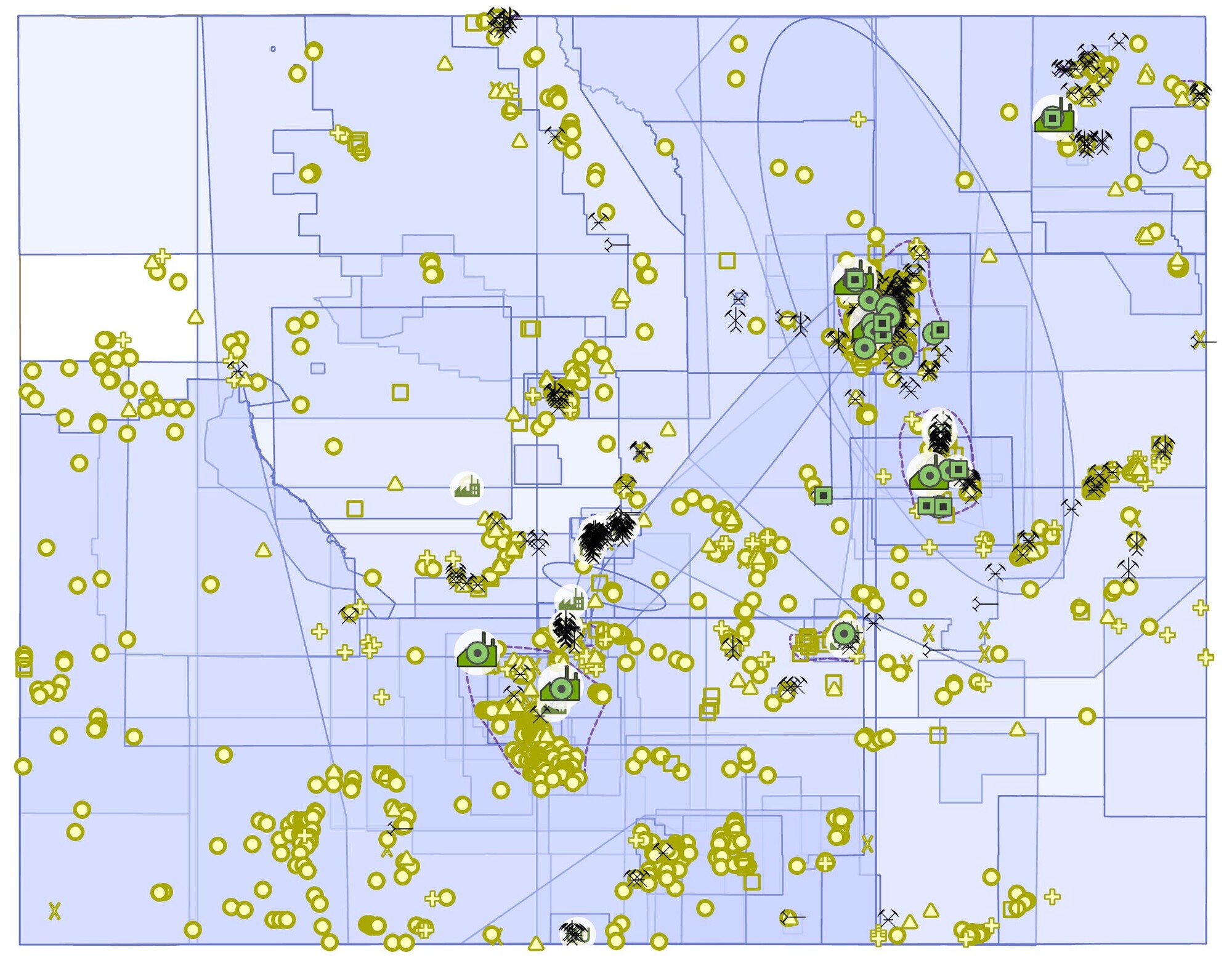 Wyoming Uranium Resources Database map showing the locations of uranium mines, deposits, historic mining districts, processing facilities, and a spatial bibliography. The database consolidates decades of exploration and geologic data into a modern, interactive format to support Wyoming’s uranium industry and research.
“Wyoming hosts the largest-known economic uranium reserves in the United States,” said WSGS Director and State Geologist Erin Campbell. “This resource is a cornerstone of domestic nuclear energy security. Accessible, high-quality data is critical as the industry reawakens.”
The database includes information on:
- Conventional uranium mines
- In-situ recovery operations
- Uranium mills and processing facilities
- Deposit occurrences and geologic context
- Historic mining districts
- A spatial bibliography linking hundreds of legacy reports
The project involved digitizing and referencing thousands of data points compiled from publications and internal WSGS files spanning the 1950s through 2010s. The effort relied heavily on the work and notes of former WSGS uranium geologists Ray E. Harris and Robert W. Gregory.
“This was more than a technical update—it was a preservation of scientific history,” said Kelsey Kehoe, WSGS geologist and project lead. “In doing so, we’ve transformed decades of legacy data into a modern, interactive resource—one that captures the full scope of Wyoming’s uranium exploration and development story.”
The release comes at a pivotal time. According to the 2024 WSGS Uranium Summary, Wyoming has accounted for nearly 50% of domestic uranium production in recent years, and three in-situ recovery mines have restarted operations due to higher uranium prices and successful sales negotiations. Facility upgrades, new wellfield development, and exploration campaigns are now actively reshaping the landscape of Wyoming’s uranium sector.
“Our goal is to support this growth with reliable science,” said Natalie Carter, WSGS geologist and project co-lead. “Whether it’s exploration, permitting, or reclamation, this database gives operators, regulators, and researchers a much-needed tool to navigate Wyoming’s uranium legacy and future.”
The Wyoming Uranium Resources Database and its associated GIS layers can be accessed on the WSGS website at: http://www.wsgs.wyo.gov.
| |
Exploring the past, empowering the future Email: |
Stay Connected
SUBSCRIBER SERVICES:
Manage Subscriptions | Unsubscribe All | Subscriber Help
| This email was sent to [email protected] using GovDelivery Communications Cloud on behalf of: Wyoming State Geological Survey · P.O. Box 1347 · Laramie, WY 82073 · 307-766-2286 |