
July 22, 2025
******FOR IMMEDIATE RELEASE******
Media Contact:
Wyoming State Geological Survey
New WSGS Data Release Aims To Improve Utility of Subsurface Geologic Data
LARAMIE, Wyo. — The Wyoming State Geological Survey (WSGS) has released new digital surfaces depicting the structure of Precambrian-age igneous and metamorphic rocks, offering a powerful tool for visualizing and analyzing Wyoming’s subsurface geology.
Geologists often map Precambrian rocks, which represent the oldest and most extensive portion of Earth's geologic record, to define the boundaries of geologic basins—a crucial first step in exploring for strategic minerals and hydrocarbons. However, their complex geological structures and deep burial have historically made them difficult to study. The development of high-resolution digital surfaces—derived from extensive geologic surveys and integrated datasets—now enables a more comprehensive and accurate knowledge of these formations. “Understanding the extents and depths to a given surface is a key driver in exploration, impacting both the technical feasibility and economics of a project,” said Jeremy Ring, WSGS geologist and project lead.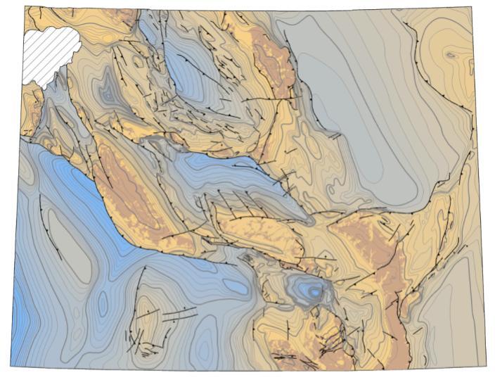 A map showing the elevation, relative to sea level, of the Precambrian rocks in Wyoming.
The data release includes two digital surfaces: the Precambrian basement structure map from Open File Report 2022-5, datumed to mean sea level, and the depth-to-Precambrian map, datumed to surface elevation from the 30-meter Digital Elevation Model (DEM) from the U.S. Geological Survey. Also included in the release is the geodatabase from OFR 2022-5, which contains the faults, contour lines, and outcrops for the original Precambrian structure map.
Dr. Erin Campbell, State Geologist and Director of the WSGS, noted that “the new digital surfaces will aid in geologic exploration in Wyoming, continuing the state’s legacy of contributing to global demands for energy and critical minerals. By combining seismic interpretations, measured sections, DEMs, and well data, the surfaces provide a cohesive, cross-disciplinary view of the state’s Precambrian geology.”
Available in a format compatible with platforms like ArcGIS Pro, the data can be seamlessly integrated into existing workflows—allowing scientists to explore Wyoming’s subsurface using modern tools to better interpret and apply the map’s structural data. Download the data package here.
| |
Exploring the past, empowering the future Email: |
Stay Connected
SUBSCRIBER SERVICES:
Manage Subscriptions | Unsubscribe All | Subscriber Help
| This email was sent to [email protected] using GovDelivery Communications Cloud on behalf of: Wyoming State Geological Survey · P.O. Box 1347 · Laramie, WY 82073 · 307-766-2286 |