|
FOR IMMEDIATE RELEASE – June 20, 2025
Press contact: Rylie Dorman, (616) 994-4774
Click here for high-resolution maps.
Ottawa County, MI — A major milestone in West Michigan’s trail network has been achieved with the completion of the Bayou Segment of the Idema Explorers Trail in Robinson Township. The six-mile Bayou Segment links over 1,000 acres of parkland and completes the western third of the Idema Explorers Trail, creating the longest continuous stretch of the trail to date. Improvements include:
- 2.4 miles of newly constructed trail through Robinson Township
- The recently expanded and dedicated Lydia Secory Verplank Memorial Bridge—a 14-foot-wide, multi-use pedestrian bridge spanning Stearns Bayou, featuring two scenic overlooks
- New wayfinding signage in Grand Haven to support navigation and connectivity
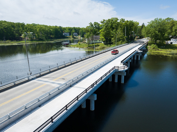 The Lydia Secory Verplank Memorial Bridge is a 14' wide multi-use pedestrian bridge over Stearns Bayou featuring two scenic overlooks. Photo courtesy of Prein&Newhof. Any external parties seeking to use these images must obtain explicit consent directly from Prein&Newhof.
🗓️ Thursday, June 26 @ 3 PM
📍14023 Green St, Grand Haven, MI
Comments begin at 3:30 PM.
This project was made possible through a combination of federal, county, and philanthropic support:
-
The federal Transportation Alternatives Program administered through MDOT: $3,428,238
-
Ottawa County ARPA: $2,000,000
-
Michigan Natural Resources Trust Fund: $300,000
-
Ottawa County Parks Foundation: $182,458
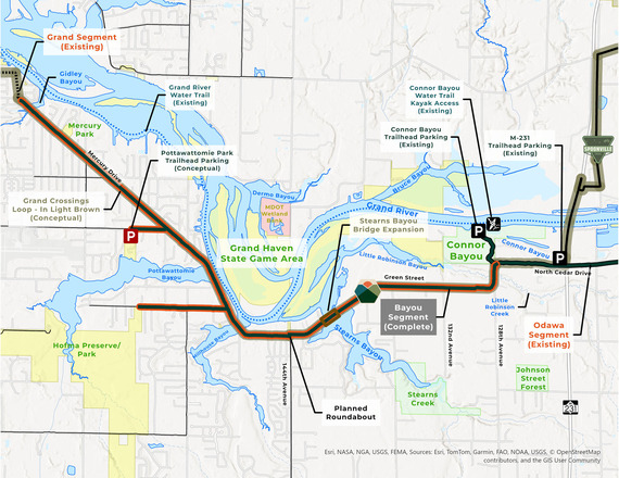 Bayou Segment Map

About the Grand River Greenway, Idema Explorers Trail
The Idema Explorers Trail, when fully completed, will span 36.5 miles, serving as the backbone of Ottawa County’s portion of the Grand River Greenway. This regional initiative aims to link Grand Haven to Grand Rapids and beyond, providing continuous non-motorized access along the south side of the Grand River.
Construction of the trail system began in 2017 and has progressed in strategic phases, thanks to extensive public and private partnerships. Several projects are slated for 2025 including the construction of the first three miles of the Bass River Segment and the construction of the 2.3-mile Eastmanville Segment. Click here to read more about these upcoming projects.
For maps, project updates, or to plan your next trail adventure, visit grandrivergreenway.org.
The Grand River Greenway is a model ecological and cultural corridor along the Grand River. It will preserve significant natural, historical, and cultural features as well as promote healthier, happier, and more vibrant communities.
|
Grand Crossings Loop
The Bayou Segment also officially completes the Grand Crossings Loop—a 24-mile continuous route that circles the Grand River between US-31 and M-231.
“The Bayou Segment of the Idema Explorers Trail completes a trail loop that has been over a decade in the making,” said Jason Shamblin, Ottawa County Parks Director. “It’s a win for our vision of providing expansive and accessible outdoor recreation opportunities while enhancing community connectivity. This trail network wouldn't have been possible without the collaboration and support of many government entities working together toward a shared goal.”
Trail Segments
Here’s a breakdown of the loop’s segments and managing entities:
Idema Explorers Trail —6.76 miles
-
164th Ave to 144th Ave — Operated by Grand Haven Township
-
144th Ave to M-231 bridge — Operated by Ottawa County Parks
Spoonville Trail — 4.27 miles
-
Nunica to North Cedar Dr — Operated by Ottawa County Parks
North Bank Trail — 6.2 miles
-
Fruitport Rd to 144th Ave — Operated by Spring Lake Township
-
144th Ave to Nunica — Operated by Crockery Township
Lakeside Trail & West End Boardwalk — 2.25 miles
-
144th Avenue to east side of M-104 bridge – Operated by Spring Village
Tri-Cities Connector — 0.21 miles
-
West side of M-104 bridge to north side of US 31 bridge – Operated by City of Ferrysburg
Idema Explorers Trail - Grand Haven Neighborhood Connector & North Shore Connector (mostly on-street) — 3.73 miles
-
164th Ave to the south side of US 31 bridge — Operated by City of Grand Haven
Key Trailheads
-
William Ferry Park – Pine Street (City of Ferrysburg)
-
Grand Trunk East – off North Buchanan Street (Village of Spring Lake)
-
Railroad Avenue Parking (Village of Spring Lake)
-
Central Park (Village of Spring Lake)
-
North Bank Trail – 144th Ave Trailhead (Spring Lake Township)
-
Nunica Junction – 112th Avenue (Crockery Township)
-
Spoonville Trail – M-231 Trailhead (Crockery Township)
-
Idema Explorers Trail – M-231 Trailhead (Robinson Township)
-
Connor Bayou County Park (Ottawa County)
-
Pottawattomie Park – Comstock Street (Grand Haven Township)
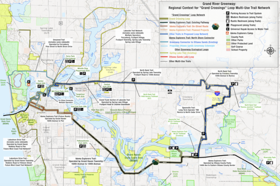 The Grand Crossings Loop is a 24-mile continuous trail that circles the Grand River between US-31 and M-231.
|