 Having trouble viewing this email? View it as a Web page.
![]()
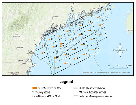
DMR is currently conducting archival passive acoustic monitoring (PAM) at 27 sites across the Gulf of Maine (GoM). At each site, there is an archival PAM mooring that collects acoustic recordings of ocean sounds. DMR is analyzing these recordings for North Atlantic right whale (NARW) vocalizations to understand when and where NARW occur in the GoM. These PAM moorings are a critical component of DMR’s expanded North Atlantic right whale (NARW) monitoring program and will contribute valuable data needed to address future federal fishing regulations.
We are asking fisherman to voluntarily avoid these buffer zones to minimize potential gear conflict with our PAM moorings to prevent significant data loss. Below is a map (Figure 1) illustrating the buffer zones of our current PAM sites.
A buffer zone of 0.076 square miles around each PAM mooring was defined to prevent unintentional damage to both the PAM mooring and fishing gear. It is recommended that vessels avoid these buffer zones when actively fishing as interactions with PAM moorings may lead to potential gear loss/damage. These buffer zones are available for download in a variety of different file formats at the State of Maine's ArcGIS Hub website. A web form will soon be available on the DMR website for submitting suggestions on PAM site relocation to help minimize the potential for gear conflict.
Figure 1 (below). A map of the buffer zones for DMR’s PAM sites. Note: Buffers have been enlarged on the map for visual purposes. Last updated 05/28/2025. Select the image for a larger version.
| This email was sent to [email protected] using GovDelivery Communications Cloud on behalf of: Maine Department of Marine Resources · 21 State House Station · Augusta, ME 04333-0021· 207-624-6550 |