| From | Vrinda Suresh <[email protected]> |
| Subject | Help us map a future for Monte Rio Redwoods📍 |
| Date | May 22, 2025 3:20 PM |
Links have been removed from this email. Learn more in the FAQ.
Links have been removed from this email. Learn more in the FAQ.
Hi John,
Maps tell stories and reflect our values as people.
As the Geographic Information Systems (GIS) Manager at Save the Redwoods League, I've always admired the science and art of modern mapmaking. In my work, maps guide important decisions that can improve the health and safety of our redwood forests, including connecting our landscapes.
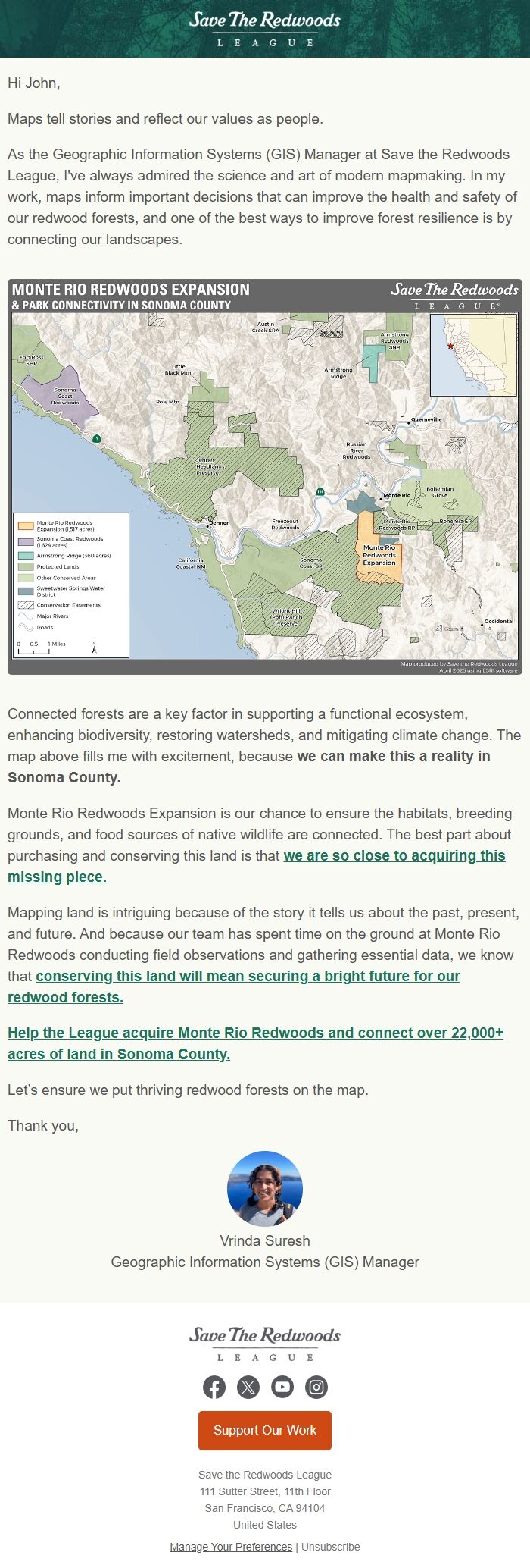
Connected forests are a key factor in supporting a functional ecosystem, enhancing biodiversity and mitigating climate change. We can make this a reality in Sonoma County.
Monte Rio Redwoods Expansion is our chance to ensure the habitats, breeding grounds, and food sources of native wildlife are connected. The best part about purchasing and conserving this land is that we are so close to acquiring this missing piece. [[link removed]]
A connected landscape is a resilient one. And because our team has spent time on the grounds of Monte Rio Redwoods, we know that conserving this land will mean securing a bright future for our redwood forests. [[link removed]]
Mapping land is always intriguing. Most importantly, it reminds me that our environments are what we make them to be.
Help the League acquire Monte Rio Redwoods and connect over 22,000+ acres of land in Sonoma County. [[link removed]]
Let’s ensure we put thriving redwood forests on the map.
Thank you,
Vrinda Suresh, Geographic Information Systems (GIS) Manager
----------
Save the Redwoods League
111 Sutter Street, 11th Floor
San Francisco, CA 94104
United States
Manage Your Preferences [[link removed]]
Unsubscribe [[link removed]]
Maps tell stories and reflect our values as people.
As the Geographic Information Systems (GIS) Manager at Save the Redwoods League, I've always admired the science and art of modern mapmaking. In my work, maps guide important decisions that can improve the health and safety of our redwood forests, including connecting our landscapes.
Connected forests are a key factor in supporting a functional ecosystem, enhancing biodiversity and mitigating climate change. We can make this a reality in Sonoma County.
Monte Rio Redwoods Expansion is our chance to ensure the habitats, breeding grounds, and food sources of native wildlife are connected. The best part about purchasing and conserving this land is that we are so close to acquiring this missing piece. [[link removed]]
A connected landscape is a resilient one. And because our team has spent time on the grounds of Monte Rio Redwoods, we know that conserving this land will mean securing a bright future for our redwood forests. [[link removed]]
Mapping land is always intriguing. Most importantly, it reminds me that our environments are what we make them to be.
Help the League acquire Monte Rio Redwoods and connect over 22,000+ acres of land in Sonoma County. [[link removed]]
Let’s ensure we put thriving redwood forests on the map.
Thank you,
Vrinda Suresh, Geographic Information Systems (GIS) Manager
----------
Save the Redwoods League
111 Sutter Street, 11th Floor
San Francisco, CA 94104
United States
Manage Your Preferences [[link removed]]
Unsubscribe [[link removed]]
Message Analysis
- Sender: Save the Redwoods League
- Political Party: n/a
- Country: United States
- State/Locality: California
- Office: n/a
-
Email Providers:
- EveryAction