| From | MN Department of Natural Resources <[email protected]> |
| Subject | Extreme fire danger continues |
| Date | May 12, 2025 11:19 AM |
Links have been removed from this email. Learn more in the FAQ.
Links have been removed from this email. Learn more in the FAQ.
Having trouble viewing this email? View it as a Web page [ [link removed] ].
minnesota department of natural resources
Extreme fire danger continues
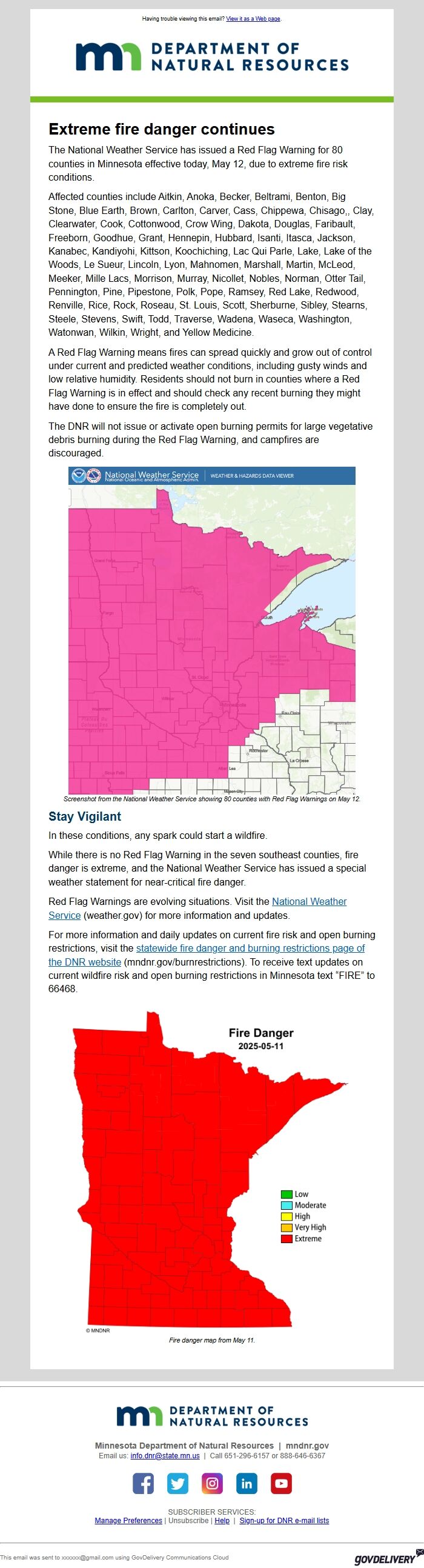
The National Weather Service has issued a Red Flag Warning for 80 counties in Minnesota effective today, May 12, due to extreme fire risk conditions.
Affected counties include Aitkin, Anoka, Becker, Beltrami, Benton, Big Stone, Blue Earth, Brown, Carlton, Carver, Cass, Chippewa, Chisago,, Clay, Clearwater, Cook, Cottonwood, Crow Wing, Dakota, Douglas, Faribault, Freeborn, Goodhue, Grant, Hennepin, Hubbard, Isanti, Itasca, Jackson, Kanabec, Kandiyohi, Kittson, Koochiching, Lac Qui Parle, Lake, Lake of the Woods, Le Sueur, Lincoln, Lyon, Mahnomen, Marshall, Martin, McLeod, Meeker, Mille Lacs, Morrison, Murray, Nicollet, Nobles, Norman, Otter Tail, Pennington, Pine, Pipestone, Polk, Pope, Ramsey, Red Lake, Redwood, Renville, Rice, Rock, Roseau, St. Louis, Scott, Sherburne, Sibley, Stearns, Steele, Stevens, Swift, Todd, Traverse, Wadena, Waseca, Washington, Watonwan, Wilkin, Wright, and Yellow Medicine.
A Red Flag Warning means fires can spread quickly and grow out of control under current and predicted weather conditions, including gusty winds and low relative humidity. Residents should not burn in counties where a Red Flag Warning is in effect and should check any recent burning they might have done to ensure the fire is completely out.
The DNR will not issue or activate open burning permits for large vegetative debris burning during the Red Flag Warning, and campfires are discouraged.
Map of Red flag counties in Minnesota
Screenshot from the National Weather Service showing 80 counties with Red Flag Warnings on May 12.
Stay Vigilant
In these conditions, any spark could start a wildfire.
While there is no Red Flag Warning in the seven southeast counties, fire danger is extreme, and the National Weather Service has issued a special weather statement for near-critical fire danger.
Red Flag Warnings are evolving situations. Visit the National Weather Service [ [link removed] ] (weather.gov) for more information and updates.
For more information and daily updates on current fire risk and open burning restrictions, visit the statewide fire danger and burning restrictions page of the DNR website [ [link removed] ] (mndnr.gov/burnrestrictions). To receive text updates on current wildfire risk and open burning restrictions in Minnesota text “FIRE” to 66468.
Fire Danger Map
Fire danger map from May 11.
________________________________________________________________________
minnesota department of natural resources [ [link removed] ]
*Minnesota Department of Natural Resources | mndnr.gov [ [link removed] ] *
Email us: [email protected] | Call 651-296-6157 or 888-646-6367
Follow us on Facebook [ [link removed] ] Follow us on Twitter [ [link removed] ] Follow us on Instagram [ [link removed] ] Find us on LinkedIn [ [link removed] ] Follow us on YouTube [ [link removed] ]
SUBSCRIBER SERVICES:
Manage Preferences [ [link removed] ] | Unsubscribe [ [link removed] ] | Help [ [link removed] ] | Sign-up for DNR e-mail lists [ [link removed] ]
________________________________________________________________________
This email was sent to [email protected] using GovDelivery Communications Cloud GovDelivery logo [ [link removed] ]
body .abe-column-block { min-height: 5px; } table.gd_combo_table img {margin-left:10px; margin-right:10px;} table.gd_combo_table div.govd_image_display img, table.gd_combo_table td.gd_combo_image_cell img {margin-left:0px; margin-right:0px;}
minnesota department of natural resources
Extreme fire danger continues
The National Weather Service has issued a Red Flag Warning for 80 counties in Minnesota effective today, May 12, due to extreme fire risk conditions.
Affected counties include Aitkin, Anoka, Becker, Beltrami, Benton, Big Stone, Blue Earth, Brown, Carlton, Carver, Cass, Chippewa, Chisago,, Clay, Clearwater, Cook, Cottonwood, Crow Wing, Dakota, Douglas, Faribault, Freeborn, Goodhue, Grant, Hennepin, Hubbard, Isanti, Itasca, Jackson, Kanabec, Kandiyohi, Kittson, Koochiching, Lac Qui Parle, Lake, Lake of the Woods, Le Sueur, Lincoln, Lyon, Mahnomen, Marshall, Martin, McLeod, Meeker, Mille Lacs, Morrison, Murray, Nicollet, Nobles, Norman, Otter Tail, Pennington, Pine, Pipestone, Polk, Pope, Ramsey, Red Lake, Redwood, Renville, Rice, Rock, Roseau, St. Louis, Scott, Sherburne, Sibley, Stearns, Steele, Stevens, Swift, Todd, Traverse, Wadena, Waseca, Washington, Watonwan, Wilkin, Wright, and Yellow Medicine.
A Red Flag Warning means fires can spread quickly and grow out of control under current and predicted weather conditions, including gusty winds and low relative humidity. Residents should not burn in counties where a Red Flag Warning is in effect and should check any recent burning they might have done to ensure the fire is completely out.
The DNR will not issue or activate open burning permits for large vegetative debris burning during the Red Flag Warning, and campfires are discouraged.
Map of Red flag counties in Minnesota
Screenshot from the National Weather Service showing 80 counties with Red Flag Warnings on May 12.
Stay Vigilant
In these conditions, any spark could start a wildfire.
While there is no Red Flag Warning in the seven southeast counties, fire danger is extreme, and the National Weather Service has issued a special weather statement for near-critical fire danger.
Red Flag Warnings are evolving situations. Visit the National Weather Service [ [link removed] ] (weather.gov) for more information and updates.
For more information and daily updates on current fire risk and open burning restrictions, visit the statewide fire danger and burning restrictions page of the DNR website [ [link removed] ] (mndnr.gov/burnrestrictions). To receive text updates on current wildfire risk and open burning restrictions in Minnesota text “FIRE” to 66468.
Fire Danger Map
Fire danger map from May 11.
________________________________________________________________________
minnesota department of natural resources [ [link removed] ]
*Minnesota Department of Natural Resources | mndnr.gov [ [link removed] ] *
Email us: [email protected] | Call 651-296-6157 or 888-646-6367
Follow us on Facebook [ [link removed] ] Follow us on Twitter [ [link removed] ] Follow us on Instagram [ [link removed] ] Find us on LinkedIn [ [link removed] ] Follow us on YouTube [ [link removed] ]
SUBSCRIBER SERVICES:
Manage Preferences [ [link removed] ] | Unsubscribe [ [link removed] ] | Help [ [link removed] ] | Sign-up for DNR e-mail lists [ [link removed] ]
________________________________________________________________________
This email was sent to [email protected] using GovDelivery Communications Cloud GovDelivery logo [ [link removed] ]
body .abe-column-block { min-height: 5px; } table.gd_combo_table img {margin-left:10px; margin-right:10px;} table.gd_combo_table div.govd_image_display img, table.gd_combo_table td.gd_combo_image_cell img {margin-left:0px; margin-right:0px;}
Message Analysis
- Sender: Minnesota Department of Natural Resources
- Political Party: n/a
- Country: United States
- State/Locality: Minnesota
- Office: n/a
-
Email Providers:
- govDelivery