This week's top posts are filled with animation, photos, and maps for your viewing pleasure. You can explore bus and streetcar maps from 1942, or see how Southwest DC changed over the decades, or read about how some streets in Tysons could be used for physical activity during our current pandemic. Choose your own reading adventure and enjoy.
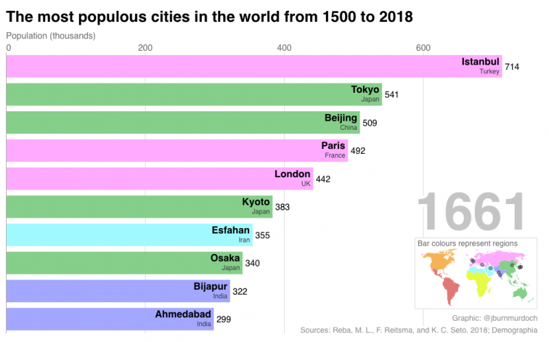
At more than 700,000 people, DC would have been the largest city in the world 500 years ago. As cities change with the times, the list of most prominent and most populated cities change too, as this mezmerizing “bar chart race” illustrates.
By Dan Malouff (Board of Directors, Editorial Board) • April 15, 2020
HistoricAerials.com is a Google Maps-like page featuring aerial imagery from decades past. Its database includes images of Washington from several years. The earliest aerials they have of the area are from 1949. It’s a fascinating way to watch neighborhoods change decade-to-decade.
Like those in a lot of other US cities, DC and surrounding areas’ best-known streetcar lines tend to be ones where service survived into the 1950’s and 1960’s. However, routes like the Washington, Gretta, & Spa Spring, which perished during the 1920’s heyday of streetcar service, often had a lasting effect on the urban landscape.
The novel coronavirus has made crowded trails dangerous, parks forbidden, and taken most traffic off the roads. Could Fairfax County and VDOT open streets to pedestrians in Tysons and surrounding areas to provide a safer alternative for people who need physical activity?