| From | [email protected] <[email protected]> |
| Subject | SEVERE WEATHER UPDATE 11am 4/20/2023 |
| Date | April 20, 2023 4:09 PM |
Links have been removed from this email. Learn more in the FAQ.
Links have been removed from this email. Learn more in the FAQ.
SEVERE WEATHER UPDATE 11am 4/20/2023
NATIONAL WEATHER SERVICE ? Ft. Worth Office
?
Anticipated time for our area 4pm ? 8pm.
?
Scattered thunderstorms are expected to develop along and ahead of a cold front this afternoon mainly along and east of I-35/I-35W. Some of these storms will be strong or severe with large hail and damaging winds as the primary threats. Isolated instances of flash flooding will also be possible across Central and East Texas this afternoon and tonight.
?
Overview
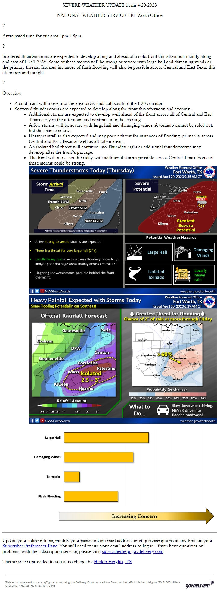
* A cold front will move into the area today and stall south of the I-20 corridor.
* Scattered thunderstorms are expected to develop along the front this afternoon and evening.
* Additional storms are expected to develop well ahead of the front across all of Central and East Texas early in the afternoon and continue into the evening.
* A few storms will be severe with large hail and damaging winds. A tornado cannot be ruled out, but the chance is low.
* Heavy rainfall is also expected and may pose a threat for instances of flooding, primarily across Central and East Texas as well as all urban areas.
* An isolated hail threat will continue into Thursday night as additional thunderstorms may develop after the front?s passage.
* The front will move south Friday with additional storms possible across Central Texas. Some of these storms could be strong.jbjbjb
________________________________________________________________________
Update your subscriptions, modify your password or email address, or stop subscriptions at any time on your Subscriber Preferences Page [ [link removed] ]. You will need to use your email address to log in. If you have questions or problems with the subscription service, please visit subscriberhelp.govdelivery.com [ [link removed] ].
This service is provided to you at no charge by Harker Heights, TX [ [link removed] ].
________________________________________________________________________
This email was sent to [email protected] using govDelivery Communications Cloud on behalf of: Harker Heights, TX ? 305 Millers Crossing ? Harker Heights, TX 76548 GovDelivery logo [ [link removed] ]
NATIONAL WEATHER SERVICE ? Ft. Worth Office
?
Anticipated time for our area 4pm ? 8pm.
?
Scattered thunderstorms are expected to develop along and ahead of a cold front this afternoon mainly along and east of I-35/I-35W. Some of these storms will be strong or severe with large hail and damaging winds as the primary threats. Isolated instances of flash flooding will also be possible across Central and East Texas this afternoon and tonight.
?
Overview
* A cold front will move into the area today and stall south of the I-20 corridor.
* Scattered thunderstorms are expected to develop along the front this afternoon and evening.
* Additional storms are expected to develop well ahead of the front across all of Central and East Texas early in the afternoon and continue into the evening.
* A few storms will be severe with large hail and damaging winds. A tornado cannot be ruled out, but the chance is low.
* Heavy rainfall is also expected and may pose a threat for instances of flooding, primarily across Central and East Texas as well as all urban areas.
* An isolated hail threat will continue into Thursday night as additional thunderstorms may develop after the front?s passage.
* The front will move south Friday with additional storms possible across Central Texas. Some of these storms could be strong.jbjbjb
________________________________________________________________________
Update your subscriptions, modify your password or email address, or stop subscriptions at any time on your Subscriber Preferences Page [ [link removed] ]. You will need to use your email address to log in. If you have questions or problems with the subscription service, please visit subscriberhelp.govdelivery.com [ [link removed] ].
This service is provided to you at no charge by Harker Heights, TX [ [link removed] ].
________________________________________________________________________
This email was sent to [email protected] using govDelivery Communications Cloud on behalf of: Harker Heights, TX ? 305 Millers Crossing ? Harker Heights, TX 76548 GovDelivery logo [ [link removed] ]
Message Analysis
- Sender: City of Harker Heights, Texas
- Political Party: n/a
- Country: United States
- State/Locality: Texas Harker Heights, Texas
- Office: n/a
-
Email Providers:
- govDelivery